- The Library Shop
- Privacy Policy
- Rules and Regulations
- Using the Internet
- Website Terms and Conditions
- Gifts of Materials to NYPL
-
© The New York Public Library, 2024
The New York Public Library is a 501(c)(3) | EIN 13-1887440
Explore 876,899 items digitized from The New York Public Library's collections.
This site is a living database with new materials added every day, featuring prints, photographs, maps, manuscripts, streaming video, and more.
Our collections include some content that may be harmful or difficult to view. Learn more
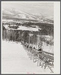
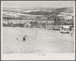
North Conway, New Hampshire, from Cranmore Mountain. Presidential range of White Mountains in distance. Skiers are taken up to the top by the skimobile. Eastern slopes ski territory
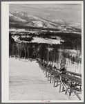
North Conway, New Hampshire, from Cranmore Mountain. Presidential range of White Mountains in distance. Skiers are taken up to the top by the skimobile. Eastern slopes ski territory
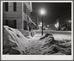
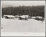
Center of town. Woodstock, Vermont. "Snowy night"
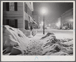
Center of town. Woodstock, Vermont. "Snowy night"
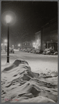
Center of town. Woodstock, Vermont. "Snowy night"
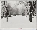
Woodstock, Vermont, on town meeting day. Woodstock, Vermont
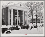
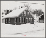
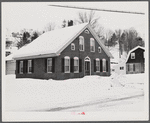
Town hall on day of town meeting. Woodstock, Vermont
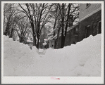
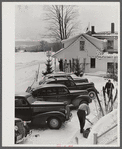
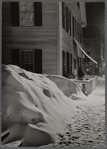
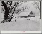
Woodstock, Vermont. Deepest snow in years piled up beside highways and sidewalks on main street
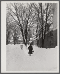
Deepest snow in years piled up beside highways and sidewalks on main street in Woodstock, Vermont
Town hall entrance on town meeting day. Movies are shown here evenings. Woodstock, Vermont
One of old homes on main street in Woodstock, Vermont
One of old homes on main street in Woodstock, Vermont
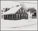
One of old homes on main street in Woodstock, Vermont
Dickinson farm and ski town tow, which costs him about one thousand dollars to install three years ago. This is the first season he has made money on it, but business in increasing rapidly now. He has a small dairy, and until last year when the hurricane
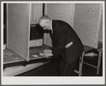
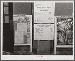
Selectman of town voting by ballot on liquor question at town meeting, Woodstock, Vermont
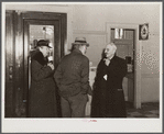
Citizens discussion town meeting in lobby of town hall. Woodstock, Vermont
Closed tourist camps near Jackson, New Hampshire
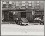
Storefronts in center of town. Woodstock, Vermont
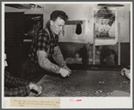
Farmer and townspeople have more leisure time to play cards in pool room during winter months. Woodstock, Vermont
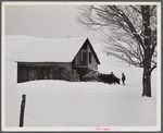
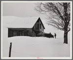
The Lodge, ski home near Mount Mansfield. Stowe, Vermont
Taking wood from snowed-under woodpile into shed with team of oxen and sled. Near Barnard, Windsor County, Vermont
Taking wood from snowed-under woodpile into shed with team of oxen and sled. Near Barnard, Windsor County, Vermont
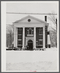
Town hall on day of town meeting. Woodstock, Vermont
Center of town. Woodstock, Vermont. "Snowy night"
Highway and farm during snowstorm near Barnard. Windsor County, Vermont


The New York Public Library recently enhanced access to all public domain items in Digital Collections so that everyone has the freedom to enjoy and reuse these materials in almost limitless ways.

Decorative prints for purchase: choose from archival prints framed art stretched canvas vintage wood and wall murals.


![Printed maps of Russia and neighboring lands, including city plans of Saint Petersburg, from the 17th to the early20th century].](https://images.nypl.org/index.php?id=2003589&t=r)


Here are some other ways you can access and engage with digital content at NYPL and beyond

Decorative prints for purchase: choose from archival prints, framed art, stretched canvas, vintage wood, and wall murals.

Contains finding aids for over 10,000 unique collections (digitized and non-digitized) in almost every conceivable format.

The online catalog of The Miriam and Ira D. Wallach Division of Art, Prints and Photographs.

The Library's digitized collections are available as machine-readable data: over 1 million objects and records for you to search, crawl and compute.

Brings together the riches of America's libraries, archives, and museums, and makes them freely available to the world.

Browse and download NYPL's digital maps, and align historic maps with the geography of today.

A tool where you can help unlock New York City's past by identifying buildings and other details on beautiful old maps.

A tool for creating and sharing 3D images from stereograph collections.

A tool for transcribing historical restaurant menus.

An initiative underway at NYPL branch libraries that aims to document, preserve, and celebrate the rich history of the New York's unique neighborhoods.

Help reconstruct theater history by transcribing old New York City playbills.

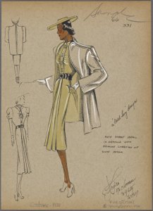
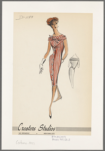
Fashion Drawings & Sketches in the Collections of FIT and the New York Public Library.

A partnership of academic & research institutions, offering a collection of millions of titles digitized from libraries around the world.